海と社に育まれる 楽しい塩竈
塩竈市について
塩竈市について
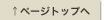
塩竈市は東北のほぼ中央部、仙台市の北東約16㎞に位置し、特別名勝松島の一画、千賀ノ浦(塩竈湾)を囲むように位置します。
市域面積は浦戸諸島を含めても17.37㎢で、人口は51,247人(令和7年10月末日現在)です。
まちの歴史は古く、市内に残る新浜遺跡、母子沢遺跡等や多くの貝塚が示すように、縄文時代から今日に至るまで、数千年にわたって、塩竈の地で人々の生活が営まれてきました。古代には陸奥の国府多賀城の津として、平安時代には歌枕の地として都人の憧れの地となり、藩政時代には鹽竈神社の門前町や漁港として栄えました。明治以降は、東北で初めての鉄道である東北本線の開通、重要港湾に指定されるなど、近代東北の玄関口として重要な役割を果たしてきました。さらに、水産・水産加工業とそれに関連する産業を基盤として、近隣市町の商業の中心地区、松島観光の基点として発展しています。
公共交通機関としてJR東北本線・仙石線の2線4駅のほか、市内を結ぶ循環バス路線や、平成22年より運行を開始したNEWしおナビ100円バスがあり、道路交通についても市内を国道45号線が縦断し、主要県道も西と南から市内に接続しています。更には三陸自動車道とのアクセスが身近となり、東北の海の玄関口に相応しい交通体系下にあります。
塩竈市では、第6次塩竈市長期総合計画(令和4年度~令和13年度)を策定しました。個性豊かで調和のとれた持続可能なまちづくりに向けて、目指す都市像に『海と社に育まれる楽しい塩竈』を掲げています。多彩な魅力を生かした楽しさあふれるみなとまちを、市民をはじめとした多くの方々と共に創り上げていくことを目指しています。
市の位置(市役所)
東経 141 度 1 分31 秒
北緯 38 度 18 分41 秒
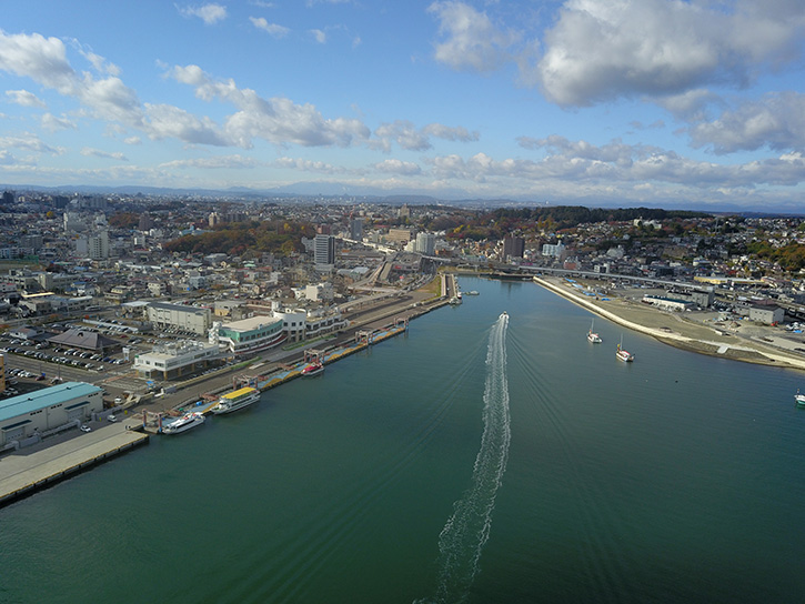
市の木 鹽竈桜 -City tree-
 里桜系八重桜。淡い紅色の大輪で、雌しべが変化した三枚の小さな葉が花の中心に見られる
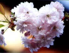
- 市の花 -City flower-
- 市章 -Emblem-

- シティプロモーションロゴマーク
JPN|ENG
About Shiogama City
Shiogama City in Miyagi Prefecture is located at the center of the Tohoku region in northeastern Japan. It is located about 16 km away from Sendai. It is located along the coastal area of Chiganoura (also known as Shiogama Bay). The city is also included as part of Matsushima, one of Japan’s Three Views of Scenic Beauty. Together with the adjacent Urato Island archipelago, the city covers a total area of 17.37 k㎡ (square kilometers). While it is the Tohoku’s smallest city, it has a considerably large population of 52,112 people as of October 2023.
With an extensive history, a number of artifacts show how people have lived here in Shiogama for thousands of years, stretching all the way from the Jomon period. These include the shell mounds from that period, as well as the Niihama and Hahakzawa ruins. Shiogama has also long served as an important geographic, strategic, and commercial hub for people in Tohoku. It was known as part of Michinoku No Kokufu Tagajo no Tsu (陸奥の国府多賀城の津), and during the Heian Period (794-1185 CE) it was known as a go-to destination for court nobles for its associations with Japanese traditional poetry. By the Edo Period (1603 – 1867 CE), Shiogama prospered as a Monzenmachi (門前町) for its association with Shiogama Jinja. It has also prospered as a vibrant fish port.
During the Meiji Period (1868 – 1912 CE), Shiogama played an important role becoming Tohoku’s transportation gateway with the opening of the Tohoku Line, the region’s first railway service. The city also became designated as an important national marine and trading port. It has also developed as a commercial hub for its neighboring cities and towns which include Tagajo, Shichigahama, and Rifu; and serves as a backbone for inbound tourism to Matsushima for its marine product-related industries.
In terms of public transportation, the city is served by the JR East Tohoku Main Line and Senseki Lines. A loop bus service also runs throughout the city in the form of the NEW SHIONAVI One Coin Bus, which has been operating since 2010. With regards to road traffic and transportation, Shiogama can be easily accessed through Japan’s National Highway 45, Miyagi Prefectural Road 104 (from the west and south exits), and the Sanriku Expressway.
As of current, Shiogama has been working on the development and growth of the community by making the most creative use of its resources. With the ambition for its residents to enjoy the city’s richness, for Shiogama to become a place where people, things and information connect via the sea and our local foods.
Location of the city(city hall)
141° 1′ 31″ E
38° 18′ 41″ N
日本語|ENG